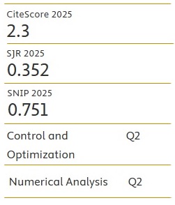
Advanced Mathematical Models & Applications
Advanced Mathematical Models & Applications is a peer-reviewed, open access journal meant to publish original and significant results and articles in all areas of mathematical modeling and their applications. The aim of this Journal is to bring together researchers and practitioners from academia and industry to establishing new collaborations in this area. The Journal will consider for publication also review articles, literature reviews, correspondence concerning views and information published in previous issues.
Leveraging the Bayesian Model's Posterior Distributions to Enhance the Accuracy of Rainfall Predictions Across Unsampled Locations
- Published: 03-12-2025
Share
Early flood detection is critical for mitigating the risk of flooding, particularly in regions prone to extreme weather events. Traditional spatial rainfall models often lack the temporal component necessary for accurate predictions, limiting their effectiveness. This study addresses these challenges by developing a Bayesian spatio-temporal model tailored to rainfall data across three distinct study areas: East Java (Indonesia), New South Wales (Australia), and the Red River Delta (Vietnam). The model integrates spatial and temporal data, enhancing its predictive capability and enabling more accurate forecasts. Specifically, we applied this model to rainfall data from these three regions, with the Inverse Distance Weighting (IDW) method used for interpolation. Rigorous statistical analysis and validation confirmed the model’s reliability in capturing moderate rainfall patterns, demonstrating strong predictive performance across varying spatial and temporal contexts. However, the model’s ability to predict extreme rainfall events remains limited, suggesting the need for further refinement. Despite this, the results highlight the model's potential for practical applications, including early flood warning systems, enhanced irrigation planning, and improved water resource management.
- View 816
- Downloads 203
- Saveds 0
- Citations (Crossref) 0